The Athens Metro system stands as Greece’s most efficient public transportation network, connecting the ancient capital with modern convenience. Whether you’re a tourist exploring archaeological wonders or a resident commuting daily, understanding the Athens Metro is essential for navigating this historic city.
Overview of the Athens Metro Network
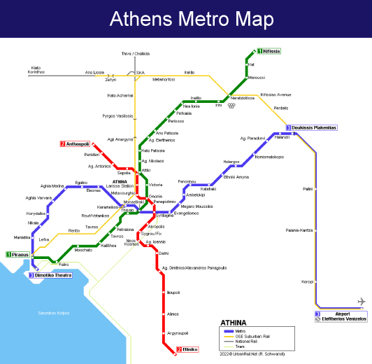
The Athens Metro consists of three lines totalling 91.7 kilometres (57.0 miles) and 66 stations: Line 1 (Green) is 25.7 kilometres (16.0 miles) long with 24 stations, Line 2 (Red) is 18.7 kilometres (11.6 miles) long with 20 stations, and Line 3 (Blue) is 47.3 kilometres (29.4 mi) long with 22 stations. This comprehensive network serves millions of passengers annually, making it one of Europe’s most important urban rail systems.
The Three Metro Lines Explained
Line 1 (Green Line) is the oldest section, originally built as a traditional railway line. It connects Kifissia in the north to Piraeus port in the south, serving key stations including Omonia and Thiseio. This line provides crucial access to the port of Piraeus, Greece’s main gateway for island ferries.
Line 2 (Red Line) runs east-west through central Athens. Omonoia, Panepistimio, Syntagma, Acropoli and Syngrou Fix are the most popular stations in Athens located in the city center and are all parts of the route the Red Line follows. The Acropoli station provides convenient access to the famous Parthenon and Acropolis Museum.
Line 3 (Blue Line) is perhaps the most tourist-friendly route, connecting the Airport with Athens’s two main central stations, Syntagma & Monastiraki. This line eliminates the need for expensive taxi rides from Athens International Airport, making it budget-friendly for travelers.
Future Expansion: Line 4
Line 4 of the Athens Metro is a future line that will run from Alsos Veikou to Goudi. Construction of the line started in mid to late-2021 and is scheduled to be completed in 2029, though realistic estimates suggest completion around 2030. This expansion will further enhance Athens’ connectivity.
Key Benefits for Tourists and Residents
The Athens Metro offers several advantages over other transportation methods. It’s faster than buses during rush hours, more affordable than taxis, and provides air-conditioned comfort during Greece’s hot summers. Many stations double as mini-museums, displaying archaeological artifacts discovered during construction.
For beach lovers, if you want to reach the Athens Riviera and the beaches, it is in the Helliniko metro station, making coastal access convenient via public transport.
Travel Tips and Accessibility
The metro operates with frequent service throughout the day, with reduced schedules on weekends and holidays. Tickets can be purchased at station machines or kiosks, with various options available for single journeys, day passes, or longer periods. The system is generally wheelchair accessible, with elevators at most modern stations.
Conclusion
The Athens Metro system represents a perfect blend of ancient heritage and modern efficiency. From airport connections to archaeological site access, it serves as the backbone of Athens transportation. As Line 4 development continues, the network will become even more comprehensive, cementing its role as an essential tool for exploring Greece’s magnificent capital city.