Boston’s public transportation system, officially known as the Massachusetts Bay Transportation Authority (MBTA) or simply “the T,” is one of America’s oldest and most comprehensive metro systems. Whether you’re a tourist exploring historic neighborhoods or a daily commuter, understanding Boston’s metro can transform your travel experience in this vibrant city.
Overview of Boston’s Metro Lines
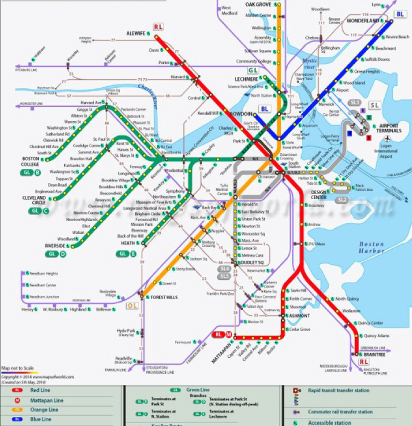
The MBTA operates four main colored rail lines that connect Boston’s core to surrounding communities. The Red Line runs north-south, linking Cambridge and Harvard University to downtown Boston and extending south to Quincy and Braintree. The Blue Line connects downtown Boston to East Boston and Logan International Airport, making it essential for air travelers.
The Orange Line travels through diverse neighborhoods from Oak Grove in the north to Forest Hills in the south, passing through downtown and Back Bay. Meanwhile, the Green Line is unique as America’s oldest subway system, featuring multiple branches (B, C, D, and E) that serve western suburbs and popular destinations like Fenway Park and Boston University.
Navigating Boston Metro Fares and Payment
The MBTA uses a modern fare system centered around the CharlieCard and CharlieTicket. CharlieCards offer the best value with reduced fares compared to cash payments. A standard subway ride costs $2.40 with a CharlieCard versus $2.90 with a CharlieTicket or cash. Weekly and monthly passes provide excellent value for frequent riders.
You can purchase and reload cards at station fare vending machines, which accept cash, credit cards, and debit cards. Many stations also feature staffed booths during peak hours for additional assistance.
Key Stations and Connections
Downtown Crossing serves as the system’s hub, where Red, Orange, and Silver lines intersect. Park Street is another crucial transfer point connecting Red and Green lines, while State Street links Blue and Orange lines. These central stations provide easy access to Boston’s Financial District, shopping areas, and historic attractions.
South Station and North Station connect metro rail to commuter rail and intercity transportation, including Amtrak services. Both stations feature extensive amenities including restaurants, shops, and parking facilities.
Tips for Boston Metro Success
Plan your route using the official MBTA app or website, which provides real-time arrival information and service alerts. During peak hours (7-9 AM and 5-7 PM), trains run more frequently but can become crowded, especially on popular routes.
Consider the Silver Line bus rapid transit for connections to Logan Airport and the Seaport District. While technically a bus system, it operates like metro rail with dedicated lanes and underground stations downtown.
Boston’s metro system operates from approximately 5 AM to 12:30 AM on weekdays, with slightly reduced weekend hours. Some lines offer limited late-night service on weekends.
Making the Most of Your MBTA Experience
The Boston metro connects you to world-class attractions including the Freedom Trail, Fenway Park, Harvard University, and MIT. Many stations feature beautiful architecture and public art, making your commute an experience itself.
Remember that Boston’s metro system reflects the city’s historic street patterns, so some routes may seem indirect. However, this comprehensive network efficiently connects neighborhoods that would otherwise require lengthy surface travel, making the MBTA an indispensable part of experiencing Boston like a local.