The Cairo Metro stands as Africa’s first subway system and the Arab world’s most extensive underground railway network. Since opening in 1987, this vital transportation system has revolutionized urban mobility in Egypt’s bustling capital, serving millions of passengers daily across Greater Cairo.
Overview of Cairo Metro Lines
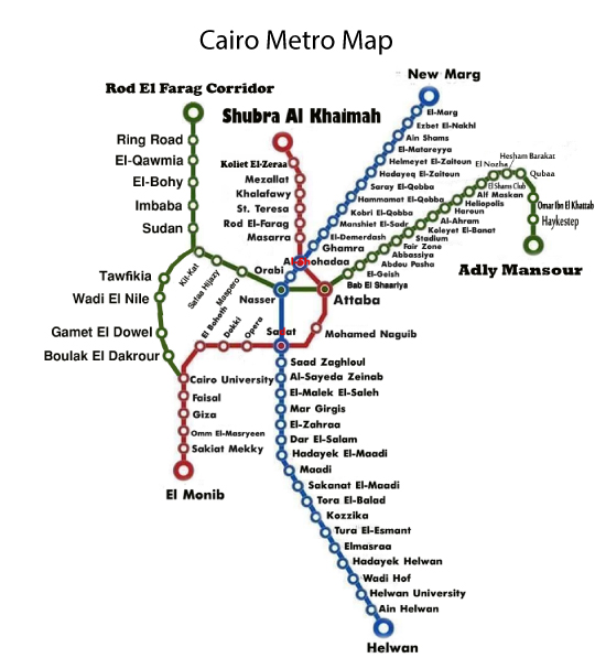
The Cairo Metro currently operates three main lines covering approximately 78 kilometers with 65 stations:
Line 1 (Red Line) runs from Helwan in the south to El Marg in the north, passing through central Cairo and connecting major districts like Maadi, Old Cairo, and Shubra. This line serves key attractions including the Egyptian Museum area and Coptic Cairo.
Line 2 (Yellow Line) extends from Shubra El-Kheima to Monib, crossing Line 1 at Sadat Station (Tahrir Square). This line provides access to important areas like Giza, Opera House, and the Nile Corniche.
Line 3 (Green Line) connects Adly Mansour in the northeast to Heliopolis and New Cairo, with future extensions planned to reach the New Administrative Capital.
Ticketing and Fares
Cairo Metro tickets are affordable, making it accessible to all economic segments. Single journey tickets cost between 3-7 Egyptian pounds (approximately $0.10-$0.25 USD) depending on the number of zones traveled. Multi-ride cards and monthly passes offer additional savings for regular commuters.
Tickets can be purchased at station ticket counters or automated machines. The system uses magnetic stripe tickets that must be inserted at entry and exit gates.
Operating Hours and Frequency
The Cairo Metro operates daily from 5:00 AM to midnight (1:00 AM on Fridays). During peak hours (7:00-10:00 AM and 4:00-8:00 PM), trains run every 2-4 minutes. Off-peak frequency extends to 5-7 minutes between trains.
Women-Only Cars
A unique feature of the Cairo Metro is its dedicated women-only cars, typically the first two cars of each train. This accommodation respects local cultural preferences and provides a comfortable travel environment for female passengers.
Key Stations and Connections
Major interchange stations include:
- Sadat Station: Connects Lines 1 and 2, located at Tahrir Square
- Nasser Station: Junction for Lines 2 and 3
- Shohadaa Station: Important connection point in central Cairo
These stations provide access to Cairo’s main tourist attractions, business districts, and transportation hubs.
Tips for Using Cairo Metro
- Avoid rush hours when possible, as trains can become extremely crowded
- Keep tickets until exiting, as they’re required at exit gates
- Respect women-only car designations
- Station announcements are in Arabic and English
- Most signs include English translations
- Download offline maps as internet connectivity may be limited underground
Future Expansion
The Cairo Metro continues expanding, with Line 3 extensions underway and new lines planned. These developments aim to reduce traffic congestion and improve connectivity to emerging districts like the New Administrative Capital.
The Cairo Metro remains an efficient, economical way to navigate Egypt’s capital while experiencing local culture and avoiding notorious Cairo traffic.