The Mexico City Metro system is one of the largest and most affordable urban transit networks in the world. Operated by the Sistema de Transporte Colectivo (STC), it connects nearly every corner of the city, making it a top choice for both daily commuters and visitors exploring the vibrant Mexican capital.
Overview of the Mexico City Metro
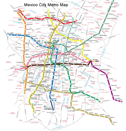
Launched in 1969, the Metro de la Ciudad de México spans over 226 kilometers with 12 color-coded lines and more than 190 stations. Each line is identified by a unique color and symbol, making navigation easy even for first-time riders. The Metro serves major districts, historic landmarks, universities, and cultural attractions.
Key Lines and Connections
- Line 1 (Pink): Runs east–west, connecting Pantitlán to Observatorio.
- Line 2 (Blue): Links Cuatro Caminos with Tasqueña, passing through the city center.
- Line 3 (Olive Green): Connects northern and southern neighborhoods via downtown.
Many stations offer transfers between lines, as well as connections to the Metrobús and light rail.
Fares and Accessibility
The Mexico City Metro is famous for its affordability, with a single ride costing just a few pesos. Passes and prepaid cards like the Tarjeta de Movilidad Integrada allow for quick entry and transfers. Most stations have signage, escalators, and some are equipped with elevators for accessibility.
Tips for Riding the Metro
- Avoid peak hours (7–9 a.m. and 6–8 p.m.) for a more comfortable experience.
- Keep belongings secure, as trains can get crowded.
- Use the women-and-children-only cars during rush hours for added safety.