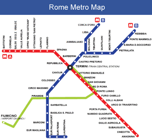
Rome’s metro system, known locally as the Metropolitana di Roma, is an essential transportation network that connects millions of visitors and residents to the city’s most iconic landmarks. Operating since 1955, this underground railway system offers an efficient and affordable way to explore the Eternal City’s rich history and vibrant culture.
Rome Metro Lines Overview
The Rome Metro consists of three main lines that serve different areas of the city:
Line A (Orange Line) runs from Battistini to Anagnina, passing through major tourist destinations including the Spanish Steps (Spagna station), Vatican City (Ottaviano station), and Termini Station. This line is particularly valuable for visitors exploring central Rome’s shopping districts and historical sites.
Line B (Blue Line) extends from Laurentina to Rebibbia/Jonio, connecting travelers to the Colosseum (Colosseo station), Roman Forum area, and Termini Station. Line B also provides access to Rome’s main airport connections and several residential neighborhoods.
Line C (Green Line) is the newest addition, currently running from Monte Compatri to San Giovanni. While still under construction, this line serves important areas including the Lateran district and connects with other metro lines at strategic interchange points.
Key Stations and Tourist Attractions
The Rome Metro strategically connects visitors to major attractions. Colosseo station on Line B provides direct access to the Colosseum and Roman Forum. Spagna station on Line A places you steps away from the Spanish Steps and luxury shopping areas. Ottaviano station offers the closest metro access to Vatican City and St. Peter’s Basilica.
Termini Station serves as the central hub, connecting both metro lines with regional trains, buses, and airport transportation. This makes it an ideal starting point for exploring Rome via public transportation.
Tickets and Operating Hours
Rome Metro operates daily from 5:30 AM to 11:30 PM (12:30 AM on Fridays and Saturdays). Single journey tickets cost €1.50 and remain valid for 100 minutes, allowing transfers between metro lines, buses, and trams within the city center.
For tourists, day passes and multi-day options provide better value. The 24-hour ticket costs €7 and includes unlimited travel on all public transportation within Rome. Weekly passes are available for extended stays.
Tips for Using Rome Metro
Purchase tickets before boarding, as validation is required. Ticket machines accept coins, bills, and credit cards, with instructions available in multiple languages. During peak hours (7-9 AM and 5-8 PM), expect crowded conditions, especially on Line A near tourist areas.
Keep belongings secure and be aware of pickpockets, particularly around major tourist stations. The metro system is generally safe, but standard urban transportation precautions apply.
Planning Your Rome Metro Journey
Download the official Roma Mobilità app or use Google Maps for real-time information and route planning. Most stations feature accessibility accommodations, though some older stations may have limited elevator access.
The Rome Metro system provides an efficient foundation for exploring the city’s countless attractions, making it an indispensable tool for any Rome visitor seeking to maximize their Italian adventure.

